Locations
Nogsta skans ancient castle
Mar
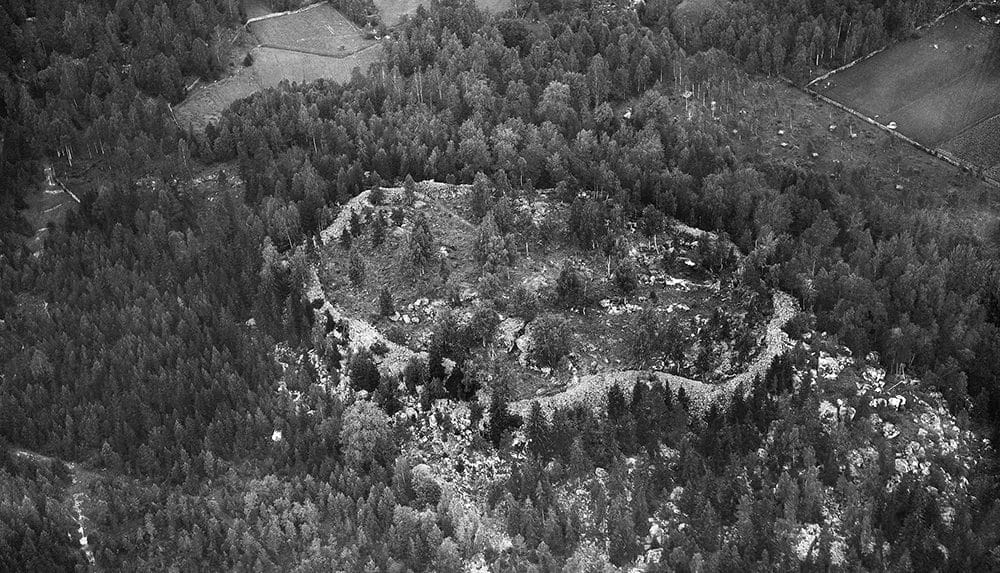
Nogsta skans or Nogsta deposit is a very large ancient castle estimated to have been built during the Iron Age, 1000-2500 years ago. It is one of several ancient castles in Odensvi parish in Västmanland.
Nogsta Skans is a very large and well-preserved castle where in many places you can still see how stones are piled on top of each other to form a straight and steep wall. Stones laid by hands more than a thousand years ago. The castle is a little difficult to reach, but well worth a visit for those who want to feel the breath of history.
The castle is 180×100 metres in size and the stone wall is 3.5-7 metres wide in places and up to 4 metres high. It is a so-called ring castle with reinforcements. The stone blocks are 0.2-1 meter in size, single blocks up to 2 meters. The wall is best preserved, and also most powerful, in the southeast. There are two entrances, one in the south-east and one in the north-west, both entrances with reinforcing walls outside.
The first written mention of Nogsta skans should be the indistriman and cultural geographer author Olof Graus Description of Wästmanland which was published in 1754:
About 1/2 mile northwest of the church [Odensvi Church] remains of a very large ancient fortress or castle were found on the territory of Nogsta village. All around the wall is built of gray stones, which down to the foundation are immense, but further up smaller.
The ancient castle is later mentioned in Historical-geographical and statistical dictionary of Sweden, fifth tape, from 1863:
A large number of stones and mounds at almost all villages and farms, as well as the legends, which are attached to hills, springs and streams, where the remains of castles are found at Nogsta village and at Stålberget, both in the north, testify to the high farming age of the place. According to Tuneld, Duke Gustaf Adolph, later King Gustaf II, in 1609 received Odensvi parish and Skogsfjerding in fief.
The National Heritage Board mentions that a runic inscription was found in the southern part of the castle, painted on a floating block with black paint (and partly difficult to read). But the runic inscription could not be found during a survey in 1988, it is thought to be possibly erased or they simply missed it. In one of the National Heritage Board's documents from 1964, this runic script is depicted, and it is a mixture of runes from both the older "Old Norse" and the younger "Viking" runic rows:

"No more detailed research has been done, however," says the National Heritage Board, so there is a chance that the rune inscription is still there, waiting for the next discoverer. So if you do visit, it might be worth taking an extra look at the moving blocks in the southern part of the castle.
Odensvi parish, in which the castle is located, lies north of Köping around Kölstaån and Valstaån. The entire Kölstaån valley is characterised by a gently rolling agricultural landscape, surrounded by large hilly forest areas. In Odensvi parish, the plain spreads out on the Mälar plain in the south, while the hilly forest rises in the north. Odensvi parish also has 20 small Iron Age burial sites and three other ancient castles. If you go back even further, to the Bronze Age, you will find many scattered graves of the rösti type, chert piles and river mills.
Name Odensvi (1351 Odhinswi) comes from the church village and contains the god name Oden and vi ('holy place, place of sacrifice'), so we can say with some certainty that it was a holy place even before the arrival of Christianity in Västmanland.
Getting there
There are no signs showing the way to the castle. You have to pass through Nogsta farm to get there. It is near the forest road which is closed with a gate. A marked path leads to the castle, which is located on the crest of a mountain in the forest.
Coordinates: Latitude 59.62087048551751 | Longitude 15.992660522460938
Discover more interesting places to visit at History map.
Subscribe to YouTube:
If you appreciate Allmogens independent work to portray our fine Swedish history and Nordic culture, you are welcome to buy something nice in the shop or support us with a voluntary donation. Thank you in advance!
Support Allmogens via Swish: 123 258 97 29
Support Allmogens by becoming a member
Support Allmogens in your will
Historical maps of Västmanland
Our wall maps are carefully restored, centuries-old maps that are reprinted in Ångermanland on matte, age-resistant, museum-quality premium paper.3% of the proceeds go directly back to our cultural heritage!


I tried to decipher the runes and wonder if some of them are not wrongly rendered because the words were so strange.
BURWFUAKITFULL
HARTAdhGG HIURdh
thRA?S MUTSUAR
?Ldh RURIIK
RISTAdhA
The last two words are clear: Ruriik carved. Where I put the question mark is a rune that I don't recognize.
I wonder if Hiurdh could be a spelling of Gerd and be the main character in the carving. Or could it be Hird?