Locations
Götavirke

Mar
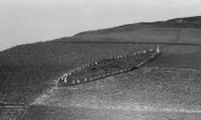
Götavirke is a more than 3.5 km long defensive wall from the Viking Age that runs north-south between Västra Husby and Hylinge in Östergötland.
Götavirke, which is C14-dated to around the year 800, is a 6-10 m wide and 0.6-2.5 m high defensive wall that covers the entire area between Lake Asplången (where the Göta Canal passes) and Lake Lill. North of Asplången there are remains of several ancient fortresses, perhaps part of the same defence works as the rampart.
On our old regional map of Östergötland the lake Aspelången is marked a bit below Norrköping, and the photo for this article is taken south of Västra Husby which is also marked on the map.
Overall, the defence system controlled access to inland Östergötland by controlling the navigable routes from the sea. A few kilometres inside the defence rampart there is also an even older defence wall running parallel to Götavirke, the so-called "Tvärdala rampart".
Parallels can be drawn to the better known and considerably larger Danevirke (Fornnordiska Danavirki), a similar defensive wall that runs across the southern part of the peninsula Jutland in Denmark and built during the same period as Götavirke.
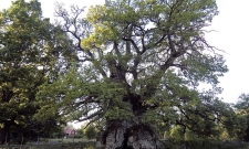
At the top of Götavirke there was originally a wooden palisade with strong posts drilled into the embankment. The palisade was according to Östergötlands Museum built of oak wood from the forests north of Lake Asplången and transported there via Storån.
On the eastern side there was also a moat 4-6 metres wide, which was kept filled with water by a control system where both Storån and Lillån could be dammed up with reeds. Inside the dike, traces of what may have been a troop transport route have been found.
Today there is not much left of the embankment, but at Hageby farm south of Västra Husby you can follow the embankment along a stretch of about 500 metres. The embankment is broken through in several places, some of which are original passages.
Along the defences there were several farms with associated burial grounds from the Viking Age. One theory that has been put forward is that each farm was responsible for maintaining the defences for the part of the rampart that affected the farm.
Watch the Östergötland County Administrative Board's video about Götavirke:
Getting there
The best preserved part of the embankment is found at Hageby farm along Östra Rydsvägen south of Västra Husby.
Coordinates: Latitude 58.4743196 | Longitude 16.1689917
Discover more interesting places to visit at History map.
Subscribe to YouTube:
If you appreciate Allmogens independent work to portray our fine Swedish history and Nordic culture, you are welcome to buy something nice in the shop or support us with a voluntary donation. Thank you in advance!
Support Allmogens via Swish: 123 258 97 29
Support Allmogens by becoming a member
Support Allmogens in your will
Historical maps of Östergötland
Our wall maps are carefully restored, centuries-old maps that are reprinted in Ångermanland on matte, age-resistant, museum-quality premium paper. 1% of the proceeds go directly back to cultural heritage!