Locations
Ales stones

Aug
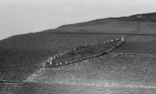
Ales stenar or Ale stones is a ship settlement at the village of Kåseberga in Valleberga parish, Ingelstads härad, on Österlen in Ystad municipality on the south coast of Skåne. The ship settlement was erected during the Late Iron Age 1,200 - 1,500 years ago.
Ales stones, or Heds stones alternatively The tomb of Urban as it is known locally, is Skåne's and Sweden's largest preserved ancient monument of the type ship settlement. It is about 67 metres long and 19 metres wide and consists of 59 stones, each weighing about 5 tonnes. Overlooking the steep coastline and Bornholm, the set towers 32 metres above the sea.
The earliest evidence for the name Ales Stenar is from 1624 and was written When Stene. In the past and still today locally the name of the place Heds stones, written 1704 Heesteena.
The meaning should probably be interpreted as Athal-ås stones, i.e. 'the stones on the mighty ridge' (Kåsebergaåsen), but also an interpretation where the prefix is a cognate of Gothic alhs 'temple' has been proposed.
The ship settlement was built during the middle period of the Iron Age, the so-called Vendel period, which got its name from the rich archaeological finds from the boat grave field in Vendel near the Vendel church north of Gamla Uppsala. But the ancestors of the Norse lived there for much longer.

A carbon-14 dating, paid for by private researcher Bob Lind, on charcoal from a hearth excavated outside the north-west limestone shows that the site was already inhabited 5300-5600 years ago.
This is also confirmed by a 2012 study showing that a so-called langdös, a stone monument, previously stood on the site just outside the shipyard. A carbon-14 dating shows that this was constructed during the Middle Neolithic period, around 5,500 years ago. It is hypothesised that some of the stones in the nave may have been reused from an earlier monument.

An interesting theory about the Ales stones was put forward in the 1970s by a private individual Hasse Alfredsson, who suggested that the monument might have had some astronomical function. Using an ordinary compass, he discovered that the ship's centre line pointed to the point on the horizon where the sun rises during the winter and summer solstices. The discovery suggested that the Ales stones may have been built as a type of solar calendar. Later measurements with better equipment by Lunda professor Göran Lind supported Hasse Alfredson's archaeoastronomical hypothesis.
Getting there
Coordinates: Latitude 55.38246999999999 | Longitude 14.054738600000064
Discover more interesting places to visit at History map.
Subscribe to YouTube:
If you appreciate Allmogens independent work to portray our fine Swedish history and Nordic culture, you are welcome to buy something nice in the shop or support us with a voluntary donation. Thank you in advance!
Support Allmogens via Swish: 123 258 97 29
Support Allmogens by becoming a member
Support Allmogens in your will
Historical maps of Skåne
Our wall maps are carefully restored, centuries-old maps that are reprinted in Ångermanland on matte, age-resistant, museum-quality premium paper. 1% of the proceeds go directly back to cultural heritage!